Showing 364 items matching land allotments
-
 Federation University Historical Collection
Document, Ballarat School of MInes Memorandum of Association
... land allotments... of association land allotments ...Ballarat School of MInes Memorandum of AssociationSigned on front 'R. Hollioake'ballarat school of mines, memorandum of association, land allotments -
Glen Eira Historical Society
Map - CAPLES PLACE SUBDIVISION
... Land Allotments... Somerset Road Prahran Grove Prahran Grove East Walk Land Allotments ...This file contains a copy of a map of the CAPLES PLACE SUBDIVISION, undated and author unknown. The map provides the dimensions of roads and allotments in the area, including also handwritten notes from the original document and others written directly onto the copy.land subdivisions, documents, maps, glen eira, caples place, caples place subdivision, land surveys, orrong road, mulgrave road, prahran grove, somerset road, prahran grove, prahran grove, east walk, land allotments, town planning, garden road -
 Brimbank City Council
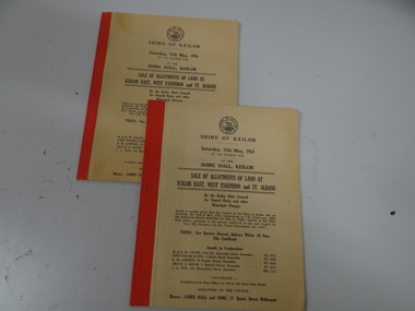
Land Sale Booklet x 2 (2 copies of the same booklet), Sale of allotments of land at Keilor East, West Essendon and St Albans 1954
... Sale of allotments of land at Keilor East, West Essendon... of allotments of land at Keilor East, West Essendon and St Albans 1954 ...land sale -
 Peterborough History Group
Map - Shire of Warrnambool
... , and includes adjoining Shire Boundaries. Shows individual land.... Shows individual land allotments. Map of the area, when ...Map of the area, when Peterborough was part of Warrnambool ShireHistoric map of the area when Peterborough was in the Warrnambool ShireA3 size map, larger view of the whole shire of Warrnambool, and includes adjoining Shire Boundaries. Shows individual land allotments.peterborough, warrnambool shire, old maps -
 Whitehorse Historical Society Inc.
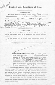
Document, Contract and conditions of sale, 1909
... . Portion of land allotment 94 known as Glebe Paddock..... Portion of land allotment 94 known as Glebe Paddock. land ...Copy of contract dated 19 April 1909 between the Freehold Investment and Banking Company of Australia Ltd and Julius Draeger. Portion of land allotment 94 known as Glebe Paddock.non-fictionland subdivision, glebe paddock, draeger, carl julius otto, freehold investment and banking company of australia ltd, t. r. b. morton & son -
 Whitehorse Historical Society Inc.
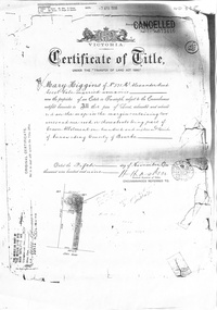
Certificate - Land Title document, Crown Allotment, 5/11/1909
... Grove Nunawading purchased by Mary Higgins. Crown Land Allotment... Mitcham melbourne Land Title document Certificate Crown Allotment ...Certificate of Title dated 5/11/1909 covering land in Shady Grove Nunawading purchased by Mary Higgins. Crown Land Allotment No. 116 Parish of Nunawading County of Bourke.land titles, higgins, mary, holmes, dave, shady grove nunawading no.76, helen -
 Whitehorse Historical Society Inc.
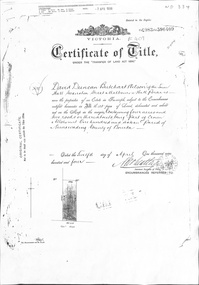
Certificate - Certificate of Title, Crown Allotment, 12/04/1904
... . Crown Land Allotment No. 116 Parish of Nunawading County... Allotment No. 116 Parish of Nunawading County of Bourke land titles ...Certificate of Title dated 12/4/1904 covering land in Shady Grove, Nunawading purchased by David Duncan Butchart Wilson. Crown Land Allotment No. 116 Parish of Nunawading County of Bourkeland titles, wilson, david duncan butchart, shady grove nunawading no. 76, higgins, mary, alcock, horace, holmes, dave, thumberstone, henry, helen -
Glen Eira Historical Society
Letter - Rosstown Railway
... , in regards to the allotment known as Webber’s. The agreement ...This file contains four items: 1/A black and white photocopy of a letter dated either 07/08/1889 or 09/08/1889, from Robert Lundon to an unidentified recipient discussing an agreement reached between the author – on behalf of the recipient – and Soon Hang Hi in regard, in regards to the allotment known as Webber’s. The agreement is outlined in the letter in what appears to be Chinese characters, and includes the marks of Robert Lundon and Soon Hang Hi. File note from Joy Wu states that the calligraphy is not Mandarin or traditional Chinese. 2/Three sheets of hand-written working notes with information taken from the Victorian Government Gazette on THE ROSSTOWN AND MURRUMBEENA LAND COMPANY LIMITED, THE ROSSTOWN JUNCTION RAILWAY AND PROSPERITY COMPANY LIOMITED, and THE ROSSTOWN JUNCTION, ELSTERNWICK, AND OAKLEIGH RAILWAY COMPANY LIMITED, covering dates between 1887 and 1894. The notes concern meetings and creditors claims relevant to the companies, with reference numbers for the information source. Date and author of the notes are not recorded. 3/A black and white photocopy of the a partial map of the Rosstown Railway and surrounding area, undated. The map includes the names of landholders in the areas of Brighton, Garden Vale and Elsternwick, as well as other railway lines present in the region. 4/A fold-out map and guide of the Rosstown Rail Trail, including a brief general history of Caulfield as well as a more extensive biography of William Murray Ross and the Rosstown Railway. The map marks and describes significant sites along the trail, including photographs of some of these sites, provided by DF Jowett.documents, correspondence, webber’s, lundon robert, chinese characters, ethnic communities, signatures, text, settlements, taxes, fraser john grieves, lovell r.h., price davies, meetings, communication activities, soon hang hi, commercial events and activities, the rosstown and murrumbeena land company limited, victorian government gazette, bulmer richard, parry john, osment henry, shareholders, creditors claims, the rosstown junction railway and property company limited, finch and best, lawyers, the rosstown junction elsternwick and oakleigh railway company limited, cameron w.c., phillips p.d., garden vale, elsternwick, elsternwick railway station, rosstown, rosstown railway, thomas street, bay street, kooyong road, melbourne and brighton railway, hawthorn road, bambra road, caulfield and frankston railway, booran road, grange road, koornang road, murrumbeena road, north road, north road railway station, east brighton railway station, south road, railway routes, railway lines, railways, land transport, murphy j., caulfield, hamilton t.f., dane p., holloway, webb, ailee john, payne t.b., brodie chas, dane john, o’neil h., mccombie john, mcmillane a., smyth c.d., cooper, ebden, landholders, jeffrey j.d., gill j., balcombe a.e., cooper h., mcnab j., white j., sutherland j., greeves a.f.a., newton m.c., chamley f.b., fowler j., inglis p., grant t., stooke j., swanson g., cochrane c., adams e.b., mccombie thas, keyes robert, brighton cemetery, burials grounds and graveyards, war-ein road, were j.b., holland j., mcmahon c., winter t.l.m., dendy henry, mitchell w., jackson s., were j.e., wickham francis dawe, bryant jane, east brighton railway station, railway stations, maps, allotments, land titles, roads and streets, rosstown rail trail, city of glen eira, tourism, trains, tourism information bureaus, tours, pamphlets, elsternwick railway park, oakleigh junction, princes park, ee gunn reserve, packer park, sites, jowett d.f., weickhardt i.g., return to rosstown: railways land sales and sugar beet ventures in caulfield, land sales, walking trails, ross william murray, transport objects, locomotion, walking, cycling, driving, sports, country mansions, people, caulfield john, builders, construction and demolition workers, occupations, careers, professionals, topography, geology, landforms, horticulture, market gardens, primary industry workers, city of caulfield, mood kee, pennington harold, annual general meetings, caulfield town hall, glen eira city council, carnegie, carnegie station, rosstown station, people by circumstance, migrants, sugar beet, sugar beet mill, sugar beet industry, mills, factories, sea beach lines, bent thomas, parliamentary representatives, neville street, miller street, lemann’s swamp reserve, koornang park, cane sugar industry, breweries, rabbit processing plants, health establishments, hospitals, food production establishments, abattoirs, thieves, social problems, vagrants, theft, squatting, financial economics, debt, finance industry, insurance companies, company managers, bentleigh, ross leila, the grange, leila road, wild cherry road, financial trouble, mortgages, gisborne street, archibald street, riddell parade, victoria railways, glen huntly road, clarence street, college street, gladstone parade, parrell street, aileen avenue, seaview street, drion estate, land subdivisions, dover street, sussex street, landfill, marara road, booran road, woodville avenue, dorothy avenue, ormond park, royal avenue, ormond railway station, oakleigh road, melten avenue, miller street, munro avenue, lord reserve, neerim road, toolambool road, the rosstown hotel, rosanna street, murrumbeena crescent, commercial establishments, the national bank, rosstown road, kangaroo road, poath road, freda street, hughesdale kindergarten, oakleigh council, hughesdale community centre, civic establishments, galbally reserve, plaques, warrigal road, out and about brochures -
 Ballan Shire Historical Society
Map - Map. Bungal, Department of Lands and Survey, Bungal, County of Grant, 09/09/1926
... . Melbourne by W. J. Butson on 9.9.1926. It shows the land allotments.... Butson on 9.9.1926. It shows the land allotments with names ...A map of Bungal in the 1920's showing the allotments, and the size, with the names of the residents. It shows the roads and the Western and Eastern Moorarbool River, and the Whipstick State Forest.Cream coloured map of Bungal in the County of Grant, bounded by the the East Moorarbool River on the East, and the State Forest on the South. It is marked with the scale of chains and the number L.358. Lithographed at the Department of Lands and Survey. Melbourne by W. J. Butson on 9.9.1926. It shows the land allotments with names of owners.Coloured pen marks and circled numbers on various areas. Price 2 shillings marked on bottom right hand edge.bungal, kerrit bareet, egerton, lal lal, borhoneyghurk, bungeeltap, ballark, yaloak, gorong, moorarbool west -
Whitehorse Historical Society Inc.
Document, Part of the history of the Lowen's, n.d
... Lowen Family bought land on Crown Allotment 100 in 1867.... of the Lowen's Lowen Family bought land on Crown Allotment 100 in 1867 ...Lowen Family bought land on Crown Allotment 100 in 1867.Lowen Family bought land on Crown Allotment 100 in 1867.Lowen Family bought land on Crown Allotment 100 in 1867.lowen family, pioneers -
 Whitehorse Historical Society Inc.
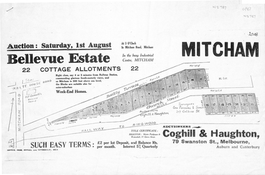
Pamphlet, Bellevue Estate, ca 1927
... Land sale of 22 allotments at Mitcham ca 1927 bounded... Mitcham melbourne Pamphlet Pamphlet Bellevue Estate Land sale ...Land sale of 22 allotments at Mitcham ca 1927 bounded by Barkly Terrace and Church Street.land sales, barkly terrace, mitcham, church street, bellevue estate, coghill & haughton -
 Bendigo Historical Society Inc.
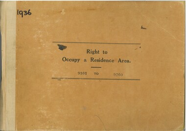
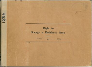
Administrative record - Right to Occupy Certificates, 1936
... the Right to Occupy certificate and the description of the land... and the description of the land including allotment, Section, City, Town ...Twelve books containing stubs of Right to Occupy Certificates for 1936. Includes name and address of person receiving the Right to Occupy certificate and the description of the land including allotment, Section, City, Town, Borough or Township and Parish name. List of record Numbers in Box 906 Some items have pencil and pen marks and ink stains.right to occupy, central victoria -
Whitehorse Historical Society Inc.
Document, Jones Family History
... relating to purchase and fencing of land, part of Crown Allotment... and fencing of land, part of Crown Allotment 116G, Lot 2, for building... relating to purchase and fencing of land, part of Crown Allotment ...Brief history of the Jones FamilyBrief history of the Jones Family from emigration of James Jones in 1852 to 1970 with papers relating to purchase and fencing of land, part of Crown Allotment 116G, Lot 2, for building of Nunawading South Primary School No 4808, including a native flora area, c 1957. Also papers from the Native Plants Preservation Society of Victoria.Brief history of the Jones Family jones, james, jones family, bette, walter edgar, lionel arthur, kones, k.e. & l.a., native plants preservation society of victoria, nunawading south primary school, no. 4808, mount pleasant road, nunawading, florists, lorikeet street, dagola court, koala avenue -
 Warrnambool and District Historical Society Inc.
Original Document, Map: Agricultural area of Ballangeich 1865, 1865
... allotments of land The area is coloured in green with scale at bottom... light card paper with black text showing allotments of land ...George Eddington arrived in Australia in 1839 and named and established property in 1841 calling the property Ballangeich after a Pass near his home town of Stirling in Scotland. It is situated 151 miles west of Melbourne and to the south of Mortlake and was originally part of the Mortlake shire, which was proclaimed 26th Jan 1864. Nearest streams are the Hopkins Riverand Lyall and Drysdale creek running through good agricultural land. This map relates to the breaking up of large runs which the Victorian government enabled through selection acts of the 1860's. The previously larger runs which were mainly cattle and sheep based were now more open to closer settlement and a greater variety in farming.The lots range in size from approximately 50 acres to around 600 acres.Some areas are set aside for reserves. By 1886 the population of Ballangeich had grown to around 600 with an hotel, three state schools and a church.Tri weekly coaches ran to Colac, Warrnambool and Camperdown providing access to supplies mail and communication. This map is typical of many which were produced in the 1860's in Victoria during a significant period of Victoria's and Warrnambool district history.Rectangular light card paper with black text showing allotments of land The area is coloured in green with scale at bottom right cornerAt the top: Plan of the Agricultural area of Ballangeich 1865 At the bottom left: Prepared by the Board of Lands & Works in accordance with the Amending Land Act 1865 Lands & Survey Office Melbourne 13th April 1865. With signaturehistory of warrnambool, ballangeich, land surveys victoria 1865, lands act 1865 victoria, ballangeich map 1865 -
 Ringwood and District Historical Society
Flyer, Land Sale Advertisement - East Ringwood Township Estates, East Ringwood, Victoria - circa 1920
... Advertisement for three retail and residential allotment... Road Ringwood North melbourne Flyer Land Sale Advertisement ...The date of the flyer as circa 1920 can be estimated from the references to the (decision on) "electrification of the Croydon Railway Line" which eventually occurred in 1923, letting of tenders for the state school building which opened in 1924, and the "proposed new railway station" (East Ringwood) which opened in 1925, Advertisement for three retail and residential allotment land sales in East Ringwood Township including maps showing layout of subdivisions. Township Estate, State School Estate, and East Ringwood Station Estate.Subdivision plans include Mount Dandenong Road, Grey Street, Eastfield Road, King Street, Everard Road, Holland Road, Purser Avenue, and Charles Street. (Agents) Spencer Jackson, Subdivider & Homebuilder, 341 Collins Street, Melbourne, Phones: M2327 (3 lines), also at Dromana, Phone 65. -
 Whitehorse Historical Society Inc.
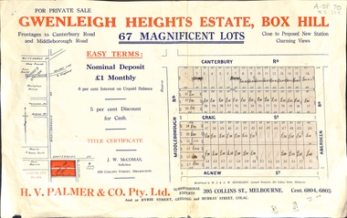
Document, Gwenleigh Heights Estate, Box Hill, unknown
... Land plan of 67 allotments for sale between Canterbury Road... Hill Land plan of 67 allotments for sale between Canterbury ...Land plan of 67 allotments for sale between Canterbury Road, Middleborough Road and Agnew Street, Box Hill. (Now Blackburn South)land subdivision, middleborough road, blackburn south, canterbury road, agnew street, aberdeen road, h. v. palmer (estate agent) -
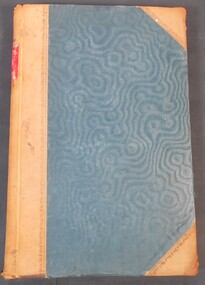
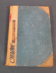 Bendigo Historical Society Inc.
Book - Reports of sales by auction
... . The book contains the purchasers' names, land section, allotments... contains the purchasers' names, land section, allotments and price ...Blue book with brown corners and spine, red label on spine with the title in gold letters "Reports of sales by auction". Letter "C" on spine. C'Maine on front cover. The book contains official Crown land sales documents, the papers are glued into the book. The book contains the purchasers' names, land section, allotments and price. Cover the period from 1893 to 1905.11/1/1893 to 12/03/06 written on the spine. Land sale reports 1880 written on inside cover. land sales, crown land, auctions -
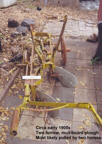 City of Moorabbin Historical Society (Operating the Box Cottage Museum)
Tool - Farm Machinery, Horse-drawn Furrow Plough, Early 20th Century
... Special Survey' of 1841 and the Crown Land Sale in 1852. Land..., land allotments were bought by pioneer settlers who established ...Late 1800s-early 1900s A horse-drawn furrow plough is an example of the type of farm implement widely used by pioneer market gardeners in the Moorabbin Shire following 'Dendy's Special Survey' of 1841 and the Crown Land Sale in 1852. Land allotments were bought by pioneer settlers who established or rented allotments for market gardens in the area. They supplied produce to the markets in St Kilda and Melbourne. During the gold-rush of the 1850s the rapidly increasing population of Melbourne saw a huge demand and a rise in prices for all foodstuffs, including the vegetables and fruit grown in the Shire of Moorabbin. This heralded a time of prosperity for market gardeners, and an equally rapid expansion of the numbers of vegetable and produce growers in the area. The 'knock-on effect" resulted in an increased interest and development of the community in the Shire of Moorabbin.Following 'Dendy's Special Survey' of 1841 and the Crown Land Sale in 1852, land allotments were bought by pioneer settlers who established or rented allotments for market gardens in the area and they supplied produce to the markets in St Kilda and Melbourne. During the gold-rush of the 1850s the rapidly increasing population of Melbourne saw a huge demand and a rise in prices for all foodstuffs, including the vegetables and fruit grown in the Shire of Moorabbin. Circa late 1800's to early 1900s. A horse-drawn furrow plough was the most common type of agricultural implement used by the pioneers of the 1800s and continued on into the 1940s when motorised tractors came into use. This plough is an example of a two furrow, mullboard plough which would most likely have been pulled by two horses. The long handle was used to lower the silver plates, (mullboards), to the chosen depth of soil. Painted yellow. Although this Box Cottage museum plough is unbranded, the most widely used plough in the Shire of Moorabbin was made by Oliver. This plough appears to be identical to that brand. brighton, moorabbin, pioneers, fruit, bentleigh, vineyards, vegetables, plough, market gardens, plow -
 Bendigo Historical Society Inc.
Legal record - Ledger of Reports of Land Sales by Auction
... section, allotment numbers and price. Ledger of Land Sales Reports... section, allotment numbers and price. Ledger of Land Sales Reports ...Blue and light brown ledger of land sales reports during 1898 to 1924. Blue water marked cover with light brown spine and corners, with red label on spine noting "12". Contains Crown Lands sales by auction documents, including purchasers' names, land section, allotment numbers and price. Ledger of Land Sales Reports 1915 sample reports of Colbinabbin, Kyabram & Rochester.land sales, auction -
Glen Eira Historical Society
Document - Bakewell Family
... taken from St Kilda Rate Book (1859-1873). It describes the land... (1859-1873). It describes the land allotment. 3/A typed ...There are 3 items about this family of early European settlers in Victoria: 1/A photocopy of an extract “Early Pioneer Families of Victoria and Riverina” – Henderson Page 441-442 The Bakewell Family of Burnewang and Tooradin”. It includes a photo of John Bakewell (1807-1888). It contains two pages and describes Bakewell’s property expansion. 2/An original copy of handwritten, unsigned undated research notes on John Bakewell property holdings taken from St Kilda Rate Book (1859-1873). It describes the land allotment. 3/A typed, unsigned, undated extract from 'The Howitts in Australia by Mary Howitt' - Mary Howitt, Vic Hist Mag 1913 Vol 3 No. 1. Reference – Memoirs of a Stockman, Harry Peck, 1853 Map, Foot Plot CCXLVI at Kooyong & Glen Eira Road. It provides a brief outline of the lives of brothers Robert and John Bakewell.the bakewell family, early pioneer families, henderson, bakewell john, port phillip, burnewang, bakewell robert, howitt godfrey dr, lord goderich, tooradin, phoebe, friends' school ackworth, yorkshire, nottingham, shaw john wyberg, plenty river, businesses, goldsbrough richard, goldsbrough mort and company ltd., glaziers, squatters, burnewang, mantons, tooradin, red bluff, torbinurruck, great swamp, brenanah, westernport, numerella, snowy river, orbost, green hills b, caramut, lyall william, mickle john, buckland john, notts, england, balderton, weddings, jane emily, howitt emanuel, farnsfield, lever mary, howitt thomas, heanor, derbyshire, howitt godfrey, scales john, exeter college oxford, downing college cambridge, guerard von, wayne john, south warnborough manor, harrison robert, lord john, jamaica, mary alice, dr. miller, miller john francis compton, emmie joan, mary emily, clifton hotel welbeck street, phoebe alice, anne edith, british museum, land values, settlements, st. kilda, elsternwick, inkerman street, st. kilda east, kew, memoirs of a stockman, harry peck -
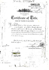 City of Moorabbin Historical Society (Operating the Box Cottage Museum)
Document - Photocopy of Land Title 1881, c1881
... . Following the 'Transfer of Land Statute' allotments in the area.... Following the 'Transfer of Land Statute' allotments in the area ...This is a Certificate of Title for an acre of land in 'Tucker's Road' purchased by Jabez Gurr in 1881, in the area that was part of the Crown Block known as Henry Dendy's Special Survey 1841, in the Parish of Moorabbin, County of Bourke, Victoria. Following the 'Transfer of Land Statute' allotments in the area of Henry Dendy's Special Survey of 1841 were sold to early settlers. This Certificate of Title shows the passage of history in Moorabbin Shire . Jabez Gurr, a wheelwright, of East Brighton, now Bentleigh East, purchased an acre of land in 'Tucker's Road' , near Centre Road, in 1881. In 1889 he sold to a produce merchant, Robert Smith, and in April 1916 this block was purchased by William Henry George Box, a market gardener and relative of William and Elizabeth Box, who owned the land until 1926. The land was then purchased by Charles John Greenlaw Coates and remained with this family until 1971. All these Family names appear on Councils and Community Boards during the foundation and development of City of Moorabbin3 photocopied pages of the Certificate of Title for approximately 1 acre of land near the corner of Centre Road and Tucker Road, Parish of Moorabbin, County of Bourke, Victoria that was part of the 5,120 acre Henry Dendy Special Survey in Brighton in 1841 and purchased in 1881 by Jabez Gurr. It records subsequent proprietors up to 1971Stamped CANCELLED 12 OCT 1994 (top Right) / Entered in the Register Book / Vol.1245 Fol. 248877/ signed Henry Crowe / Assistant Registrar of Titles / Coat of Arms / VICTORIA / Certificate of Title / UNDER THE ' TRANSFER OF AND STATUTE' /dated ' eleventh day of April one thousand eight / hundred and eighty one' / signed 'Henry Crowe' / Assistant Registrar of Titles/ ENCUMBRANCES REFERRED TO / circular Stamp 'OFFICE OF TITLES VICTORIA' / Drawn and shaded on the left side is the area of land in "Tucker's" Road 3331/3 links fro Centre Road, 150 links x 6662/3 links / The measurements are in linksdendy henry, dendy's special survey 1841, brighton, moorabbin, bentleigh, market gardeners, early settlers, pioneers, wheelwrights, merchants, fruit gardens, markets, smith robert, box william henry george, gurr jabez, county of bourke, victoria, melbourne, land statutes, tucker road, centre road, box william, box elizabeth, box cottage museum -
Whittlesea Historical Society Inc.
Document - Receipt, Yan Yean Public Cemetery, 1892
... Yan Yean Public Cemetery receipt for Allotment of Land... for Allotment of Land for the deceased Jas H. Lockwood. Dated 1892. yan ...Yan Yean Public Cemetery receipt for Allotment of Land for the deceased Jas H. Lockwood. Dated 1892.A small paper receipt, 1 of 2 items pinned togetherSigned by James Ryan Jnr, Secretary.yan yean cemetery, james h lockwood -
 Bendigo Historical Society Inc.
Administrative record - Right to Occupy Certificates
... to Occupy certificate and the description of the land including... of the land including allotment, Section, City, Town, Borough ...Ten books containing stubs of Right to Occupy Certificates for 1936. Includes name and address of person receiving the Right to Occupy certificate and the description of the land including allotment, Section, City, Town, Borough or Township and Parish name. Two blue covered books used for Substitute Right to occupy certificates. One book, stubs only, dated 1976 - 1981. One with four stubs dated 1981 - 1983. Four stapled bundles of stubs dated 1937 - 1971 issued for Replacement Rights. Includes names and Receipt numbers. Yellow foolscap sheet Listing reord numbers of Rights issued during 1936 and 1937.Some items have pencil and pen marks and ink stains.right to occupy, central victoria -
Clunes Museum
CERTIFICATE, SWAINSON FAMILY, STATEMENT OF RECEIPTS AND EXPENDITURE
... STREET, CLUNES. THAT BEING SALE OF ASSET/S, LAND AND DWELLING.... THAT BEING SALE OF ASSET/S, LAND AND DWELLING, BEING ALLOTMENT 11 ...CERTIFICATE OF ESTATE FROM THE SWAINSON FAMILY HOME IN HILL STREET, CLUNES. THAT BEING SALE OF ASSET/S, LAND AND DWELLING, BEING ALLOTMENT 11, SECTION 6, TOWNSHIP OF CLUNES, PARISH OF CLUNES, COUNTY OF TALBOT. SOLD TO MRS. C.K. BUCHANAN..1 THE BALLARAT TRUSTEES EXECUTORS & AGENCY COMPANY LIMITED. STATEMENT OF RECEIPTS & EXPENDITURE FOR AND ON A/C OF ESTATE OF JOHN SWAINSON DECEASED DATED 23/9/1919 .2.3 PHOTOCOPIES OF THE BALLARAT TRUSTEES EXECUTORS & AGENCY COMPANY LIMITED. ESTATE OF JOHN SWAINSON DECEASED DATED 23/9/1919 .4 COVER LETTER FROM THE BALLARAT TRUSTEES EXECUTORS & AGENCY COMPANY LIMITED TO MRS. L.E. SWAINSON WIDOW OF JOHN SWAINSON DATED 17/10/1918 CHEQUE IN THE AMOUNT OF 93 POUNDS, 19 SHILLINGS AND ZERO PENCE IN LIEU OF THE SIGNED RELEASE.local history, document, certificates, swainson family, mrs. c k buchanan -
 Greensborough Historical Society
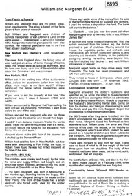
Article - Article, Newsletter, Janeen O'Connell, William and Margaret Blay, by Janeen O'Connell, 2022
... Land to an allotment at Greenhills on the Plenty River in 1841... Land to an allotment at Greenhills on the Plenty River in 1841 ...The Blays moved from their farm in New Norfolk, Van Diemens Land to an allotment at Greenhills on the Plenty River in 1841, but William was injured in a fall and was unable to work this farm, which was repossessed by the bank, causing him to fall into a severe depression and subsequently admitted to Yarra Bend Insane Asylum, where he died in 1849. Article first published in "Pioneer Echo" no 226, Oct-Nov 2022.1 p. typescript, copied from newsletterblay family, william blay, greenhills -
 Bendigo Historical Society Inc.
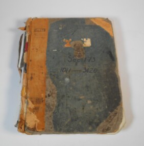
Book - Application for allotments for sale 1908-1974
... the applications for allotments of land for sale. The headings in the book... the applications for allotments of land for sale. The headings in the book ...Green cover book with brown leather spine. The book lists the applications for allotments of land for sale. The headings in the book are: number of application, date of registry, date of application, surname, Christian name and address, parish, allotment, section, area, local land board schedule, classification, crown grant, references and remarks. It covers the years 1908 -1974.Spine has a red label with gold letters. On the cover the remnants of a label, under in ink Sec.173, 1011-3420. At top left of the cover Sec.171 SHland sales, govrnment -
 Bendigo Historical Society Inc.
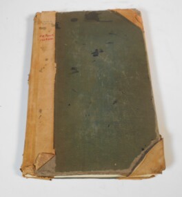
Book - Land sales applications
... the applications for allotments of land for sale. The headings in the book... name and address, parish, allotment, section, area, local land ...Green cover book with brown leather spine. The book lists the applications for allotments of land for sale. The headings in the book are: number of application, date of registry, date of application, surname, Christian name and address, parish, allotment, section, area, local land board, Licence dated, licence issued, references and remarks. The book covers the years 1908-1960.On the cover in black ink "Castlemaine" and in red ink "138 front, 130 Rear" On the first page in pen: 138-129 front 130-121 back.land sales, castlemaine -
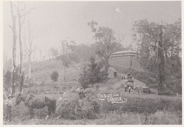 Mt Dandenong & District Historical Society Inc.
Photograph, The Busy Corner, 1907
... “Jeeves Saddle” in 1907. Isaac Jeeves special strip of land.... Isaac Jeeves special strip of land Crown Allotment “C” 7 chains ...View of Jeeves Saddle in 1907 showing everyday life and including important people and businesses from early settlement - Dodd's grocery and meat cutting carts; Beulah tea Rooms/Post Office; Mrs Hand, Fred Jeeves, Theo Hand.This photograph has a detailed inscription on the back handwritten by John Lundy-Clarke in 1974.“Jeeves Saddle” in 1907. Isaac Jeeves special strip of land Crown Allotment “C” 7 chains wide, lay between the sledge load of pea stalks and the far end of the verandah on Mrs Hand’s “Beulah Tea Rooms” which soon afterwards became the Mt Dandenong North Post Office. The coach road came up from the right behind the tall stump. The big woman in black was Mrs Hand. The wagon at the shop was Dodd’s grocery cart. The nearer wagon was the first coach on the mountain which had belonged to Briarty. The small cart was Dodd’s meat cutting cart. The elm trees are in the centre of the picture and above them is Price’s sign advertising their shop and newsagency. The big house is “Mountjoy” burnt 1975. Walker’s house is among the big trees left centre. Boy at horse’s head is Fred Jeeves. Boy on sledge is Theo Hand. The horse is “Blossom”. Barbers Road goes to the left from behind the elm trees.jeeves, theo hand, fred jeeves, isaac jeeves, barbers road, beulah tea rooms, post office, mount dandenong north, mt dandenong north, kalorama, coach, mountjoy -
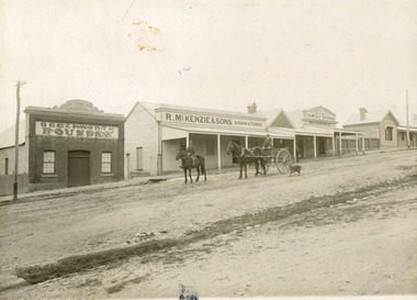 The Beechworth Burke Museum
Photograph, 1910
... out plans for new roads and building allotments. Land was sold... out plans for new roads and building allotments. Land was sold ...Taken in 1910, this photograph depicts a scene of Bridge road in Newtown, Beechworth. Walking on the road are two men on horseback, one of which is pulling a carriage with a small dog standing beside it. Behind them are a line of small buildings and shops. Small industries began to expand dramatically in Beechworth, particularly during the 1860s, leading to a strengthening of the towns economy. As early as 1853, areas surrounding the waterway known as Spring Creek were surveyed with the intent of mapping out plans for new roads and building allotments. Land was sold and new buildings were erected, creating an expansion of the Beechworth township and retail services. One building shown in this photograph is Straughair and Duncan's Beechworth Foundry. This business was established in 1858 through the partnership of Mark Straughair and John Duncan. It dealt mostly in the manufacturing of castings and mining machinery, receiving orders from all over the Ovens district. The Business eventually collapsed after the deaths of Straughair in 1882 and Duncan in 1896 but was reopened by W.H. Phillips in 1905. The two other buildings are both associated with the name McKenzie. Evidence suggests that the McKenzie family has a long association with the town of Beechworth. This photograph is historically significant as it provides insight into the nineteenth and twentieth century industrial expansions that happened in the area of Newtown, leading to the urbanisation of Beechworth. Black and white rectangular photograph printed on matte photographic paper mounted on card.Reverse: Newton / 1997.2648 / 33 Newton Beechworth / 84-219-1 / McKenzies / BMM3055 / newtown beechworth, bridge road, 1910, j. duncan, r. mckenzie, m. straughair, industrial growth, ford street, beechworth foundry, straughair and duncan, mckenzie and sons grainstore, mckenzie family store -
 Kew Historical Society Inc
Plan, Melbourne & Metropolitan Board of Works : Borough of Kew : Detail Plan No.1575, 1905
... allotments of land. Many of these mansions are identified by name... built on large allotments of land. Many of these mansions ...The Melbourne and Metropolitan Board of Works (MMBW) plans were produced from the 1890s to the 1950s. They were crucial to the design and development of Melbourne's sewerage and drainage system. The plans, at a scale of 40 feet to 1 inch (1:480), provide a detailed historical record of Melbourne streetscapes and environmental features. Each plan covers one or two street blocks (roughly six streets), showing details of buildings, including garden layouts and ownership boundaries, and features such as laneways, drains, bridges, parks, municipal boundaries and other prominent landmarks as they existed at the time each plan was produced. (Source: State Library of Victoria)This plan forms part of a large group of MMBW plans and maps that was donated to the Society by the Mr Poulter, City Engineer of the City of Kew in 1989. Within this collection, thirty-five hand-coloured plans, backed with linen, are of statewide significance as they include annotations that provide details of construction materials used in buildings in the first decade of the 20th century as well as additional information about land ownership and usage. The copies in the Public Record Office Victoria and the State Library of Victoria are monochrome versions which do not denote building materials so that the maps in this collection are invaluable and unique tools for researchers and heritage consultants. A number of the plans are not held in the collection of the State Library of Victoria so they have the additional attribute of rarity.Original survey plan, issued by the MMBW to a contractor with responsibility for constructing sewers in the area identified on the plan within the Borough of Kew. The plan was at some stage hand-coloured, possibly by the contractor, but more likely by officers working in the Engineering Department of the Borough and later Town, then City of Kew. The hand-coloured sections of buildings on the plan were used to denote masonry or brick constructions (pink), weatherboard constructions (yellow), and public buildings (grey). Plan No.1575 shows that in the area bounded by Wellington Street, Edgevale Road, Glenferrie Road, and Cotham Road, there had already been significant subdivision of land and houses constructed. As one of the highest points in Kew, as expected, there were already some significant mansions built on large allotments of land. Many of these mansions are identified by name on the plan such as ‘Kelso’, ‘Abbotsford’, ‘Clarendon’ and ‘Ashlyn’ in Cotham Road. Other houses of equal size are unnamed on the plan.melbourne and metropolitan board of works, detail plans, maps - borough of kew, mmbw 1575, cartography